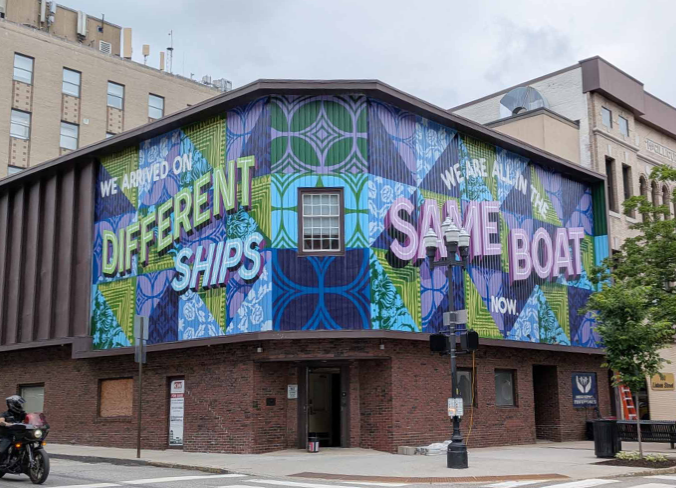
https://apnews.com/article/mural-exhibit-history-mexico-city-art-

What's Your Story?
ALASKAA Smithsonian magazine special report
The 8,000-year-old rock carvings were likely created by the Tlingit
Water laps gently against the rocky shores of Petroglyph Beach State Historic Site in Wrangell, an island town that’s part of Alaska’s Inside Passage, an archipelago that drips like a chain of pearls along the state’s southeast coast. I have to watch my footing as I amble along the beach, dodging thousands of craggy rocks that are beginning to poke up out of the sand.It’s a sunny summer morning in late August, and the tide has already gone out for the day, exposing a rocky wonderland ripe for exploration. Unlike at most beaches, where people go to comb for seashells or sea glass, here I’m on the hunt for the dozens of petroglyphs that pepper the coastline’s boulders and bedrock. (The word petroglyph is derived from the Greek words petra and glyph, which translate to “rock” and “carving.”)
While there are numerous hypotheses about the origins of the more than 40 rock carvings etched here—one of the highest known concentrations of petroglyphs in Alaska and around the world—the one most often agreed upon by archaeologists is that they were etched roughly 8,000 years ago by the Tlingit (pronounced CLINK-it), an Alaska Native group that continues to inhabit the state’s southeastern archipelago. But when it comes to the petroglyphs’ intended purpose, that’s where things remain a mystery.
According to a placard at the beach’s entry, the petroglyphs may have served any number of purposes, including being territorial markers to warn enemies that they were encroaching on settled land, a historical record commemorating a significant event such as a battle or an epic tidal wave that happened here, or underwater beacons to help coax salmon to swim to the mouths of the rivers and streams that feed into the Inside Passage straits. Others believe the drawings mark an important fishing site or settlement.“These specific symbols are very unique to Southeastern Alaska,” says Nicholas Schmuck, a special projects archaeologist with the Alaska Department of Natural Resources. “Every time you get a good storm, they can become buried and then later exposed. They also come and go with the tides, causing them to disappear and reappear.”The several-acre site officially became a state park in 2000. The petroglyphs are accessible via a wooden boardwalk that meanders down toward the rocky beach. On the surface, the site looks like any other beach in the area—especially when the tide is in, hiding the petroglyphs. But once the water retreats, searching for the drawings is much like an Easter egg hunt, with each artwork popping up when least expected. It’s possible there were once more than the 40 petroglyphs currently found at the beach, but tides over the centuries likely washed them away.
The best time to see the petroglyphs is at low tide, so I use the local tide tables provided by the National Oceanic and Atmospheric Administration as reference. Since my visit is during the summer, I aim to be at the beach earlier in the day.It’s important to note that damaging or stealing the petroglyphs is considered a crime, and the artworks are protected under the Alaska Historic Preservation Act.
The first carving I come across is a perfectly etched spiral, which immediately reminds me of the doodles I used to draw in the margins of my homework back in school. I pour some water from my water bottle onto the petroglyph to get a better look, since they appear more vibrant when wet. As I continue exploring the beach, I stumble upon a cluster of petroglyphs, including a cartoonish-looking face with two ginormous eyes, what appears to be a fish or whale replete with detailed fins and a bird that called to mind a flamingo perched on one foot.I try to imagine what these ancient people were trying to communicate with their meticulously carved drawings. Did they know that thousands of years later this beach would become a popular tourist attraction? So much so that Wrangell commissioned Dick Stokes, a local Tlingit artist, to recreate some of the petroglyphs. Thanks to his recreations, visitors like myself can make rubbings using carbon paper without damaging the original pieces of artwork.When I talk to Schmuck on the phone a few weeks after my visit, I ask him what his take is on the petroglyphs’ purpose and whether there are any clues that can help people like myself better understand their meaning.
“Wrangell is pretty exceptional when it comes to its abundance of petroglyphs,” Schmuck says. “If you look at [Tlingit] clan houses, they each have different crests. So, it’s possible that each of these petroglyphs are a different symbol for the clan.”As an example, Schmuck mentions a drawing that I first thought was a fish but he says is more likely an orca (or killer whale), a common symbol used by the Tlingit on their meeting houses and totem poles.
“That one stands out because it was drawn in the Tlingit style,” he says. Also known as Northwest Coast art, this style of artwork contains curved thick and thin lines known as formlines. Ovoids (egg-like shapes), U forms and S forms often depict animals and people.The Tlingit are accomplished carvers, evidenced by the many totem poles towering over the region. Like the totem poles, which often contain symbolic imagery depicted in family crests, the petroglyphs feature similar animals, such as killer whales, thunderbirds, salmon and ravens. Was it possible that a Tlingit artisan thousands of years ago was practicing their artistry by chiseling it into the beach rocks before applying their carving skills to an even bigger artwork?
It’s unlikely anyone will ever know the true intent of these petroglyphs, which simply adds to their mystery.
A Smithsonian magazine special report
The 8,000-year-old rock carvings were likely created by the Tlingit
Travel CorrespondentMarch 22, 2023
Water laps gently against the rocky shores of Petroglyph Beach State Historic Site in Wrangell, an island town that’s part of Alaska’s Inside Passage, an archipelago that drips like a chain of pearls along the state’s southeast coast. I have to watch my footing as I amble along the beach, dodging thousands of craggy rocks that are beginning to poke up out of the sand.
It’s a sunny summer morning in late August, and the tide has already gone out for the day, exposing a rocky wonderland ripe for exploration. Unlike at most beaches, where people go to comb for seashells or sea glass, here I’m on the hunt for the dozens of petroglyphs that pepper the coastline’s boulders and bedrock. (The word petroglyph is derived from the Greek words petra and glyph, which translate to “rock” and “carving.”)
Report an ad
While there are numerous hypotheses about the origins of the more than 40 rock carvings etched here—one of the highest known concentrations of petroglyphs in Alaska and around the world—the one most often agreed upon by archaeologists is that they were etched roughly 8,000 years ago by the Tlingit (pronounced CLINK-it), an Alaska Native group that continues to inhabit the state’s southeastern archipelago. But when it comes to the petroglyphs’ intended purpose, that’s where things remain a mystery.
According to a placard at the beach’s entry, the petroglyphs may have served any number of purposes, including being territorial markers to warn enemies that they were encroaching on settled land, a historical record commemorating a significant event such as a battle or an epic tidal wave that happened here, or underwater beacons to help coax salmon to swim to the mouths of the rivers and streams that feed into the Inside Passage straits. Others believe the drawings mark an important fishing site or settlement.
“These specific symbols are very unique to Southeastern Alaska,” says Nicholas Schmuck, a special projects archaeologist with the Alaska Department of Natural Resources. “Every time you get a good storm, they can become buried and then later exposed. They also come and go with the tides, causing them to disappear and reappear.”
The several-acre site officially became a state park in 2000. The petroglyphs are accessible via a wooden boardwalk that meanders down toward the rocky beach. On the surface, the site looks like any other beach in the area—especially when the tide is in, hiding the petroglyphs. But once the water retreats, searching for the drawings is much like an Easter egg hunt, with each artwork popping up when least expected. It’s possible there were once more than the 40 petroglyphs currently found at the beach, but tides over the centuries likely washed them away.
Report an ad
The best time to see the petroglyphs is at low tide, so I use the local tide tables provided by the National Oceanic and Atmospheric Administration as reference. Since my visit is during the summer, I aim to be at the beach earlier in the day.
It’s important to note that damaging or stealing the petroglyphs is considered a crime, and the artworks are protected under the Alaska Historic Preservation Act.
The first carving I come across is a perfectly etched spiral, which immediately reminds me of the doodles I used to draw in the margins of my homework back in school. I pour some water from my water bottle onto the petroglyph to get a better look, since they appear more vibrant when wet. As I continue exploring the beach, I stumble upon a cluster of petroglyphs, including a cartoonish-looking face with two ginormous eyes, what appears to be a fish or whale replete with detailed fins and a bird that called to mind a flamingo perched on one foot.
I try to imagine what these ancient people were trying to communicate with their meticulously carved drawings. Did they know that thousands of years later this beach would become a popular tourist attraction? So much so that Wrangell commissioned Dick Stokes, a local Tlingit artist, to recreate some of the petroglyphs. Thanks to his recreations, visitors like myself can make rubbings using carbon paper without damaging the original pieces of artwork.
When I talk to Schmuck on the phone a few weeks after my visit, I ask him what his take is on the petroglyphs’ purpose and whether there are any clues that can help people like myself better understand their meaning.
Report an ad
“Wrangell is pretty exceptional when it comes to its abundance of petroglyphs,” Schmuck says. “If you look at [Tlingit] clan houses, they each have different crests. So, it’s possible that each of these petroglyphs are a different symbol for the clan.”
As an example, Schmuck mentions a drawing that I first thought was a fish but he says is more likely an orca (or killer whale), a common symbol used by the Tlingit on their meeting houses and totem poles.
“That one stands out because it was drawn in the Tlingit style,” he says. Also known as Northwest Coast art, this style of artwork contains curved thick and thin lines known as formlines. Ovoids (egg-like shapes), U forms and S forms often depict animals and people.
The Tlingit are accomplished carvers, evidenced by the many totem poles towering over the region. Like the totem poles, which often contain symbolic imagery depicted in family crests, the petroglyphs feature similar animals, such as killer whales, thunderbirds, salmon and ravens. Was it possible that a Tlingit artisan thousands of years ago was practicing their artistry by chiseling it into the beach rocks before applying their carving skills to an even bigger artwork?
Report an ad
It’s unlikely anyone will ever know the true intent of these petroglyphs, which simply adds to their mystery.
Tuesday, April 4 • 1:00 PM
WHO NEEDS A STATUE?
Presenter: Margy Burns Knight
January 4, 2023
Volunteers have now tracked down at least one photo for every one of the more than 58,000 U.S. military service members who died in the Vietnam War – for an online Wall of Faces project that took more than two decades to complete.
The goal was to help a new generation of Americans grapple with sacrifice and inspire them to reflect, perhaps, on “why we have a wall” with names inscribed on it, say organizers from the Vietnam Veterans Memorial Fund (VVMF), the nonprofit that spearheaded the digital project as well as the national monument on which all these names are engraved.
More than half of the visitors to the memorial in Washington, D.C., today weren’t alive when it was commissioned in 1982, they add.
A volunteer labor of love has resulted in something remarkable: an online photo archive of every U.S. military service member killed in Vietnam, bringing their humanity home to current and future generations.
Over the years the picture-gathering process could be fraught: Relatives were sometimes reluctant to share photos of loved ones killed in battles picked by a government their survivors had come to distrust.
And stock photos taken straight out of, say, boot camp graduation can be surprisingly tough to come by. “The military doesn’t just sit there and funnel pictures to you,” says Herb Reckinger, a volunteer.
So tracking them down often involved investigative dedication, reaching out to local librarians, scouring yearbooks, and, at one point, combing through microfiche for a grainy image of a high schooler orphaned and homeless before he was drafted.
The project evolved into a quest, too, for photos that were actually good – meaning they showed a little personality, says Tim Tetz, director of outreach at VVMF.
Seeing young people in their prime, before they were soldiers, kicking back on a beach, cradling a newborn niece, or “sitting through that awkward school photo where their mom made them wear a funny sweater gets you to realize that they went through the same milestones and moments that each of us have gone through and really brings the sacrifice home,” he says. “You see the impact this war had on so many.”
Along the way, Mr. Tetz adds, the project “has provided some healing we didn’t envision when we started.”
from Wall of Faces website
An image from the Wall of Faces website created by the Vietnam Veterans Memorial Fund. The group has reached its goal of obtaining photos of each member of the armed services killed during the war in Vietnam, putting faces to all the names on the Vietnam Veterans Memorial in Washington, D.C.
When Mr. Reckinger, a retired oil refinery worker with a midwesterner’s disarming niceness, started volunteering for the Wall of Faces project, there were roughly 300 Minnesotans killed in the war without a picture on their VVMF profile.
He pasted a state map on cardboard and hung it on the wall with sticky notes marking their hometowns. Occasionally making “two or three trips for one guy,” since 2014 he’s dug through local historical society archives and teamed up with librarians to track down photos for 250 soldiers lost in the war.
Recommended
Mr. Reckinger drew a “very low” draft lottery number for the Vietnam War, “but I joined the Navy Reserve for 5 or 6 years so as not to get drafted – I’m not extremely proud of it,” he says.
He’s one of a couple of dozen volunteers who spent several hours a day, and sometimes more, hunting for photos in Minnesota and, when that job was done, other states, joining a band ultimately totaling thousands of volunteers who helped in the collection effort.
Now that the project is complete, their job has evolved into finding more and better photographs for each of the names inscribed on the wall. “I always felt that the Vietnam soldiers deserved better,” Mr. Reckinger says. “I’m trying to see what a 70-year-old guy sitting in his basement can do.”
It turns out to be a fair amount. After the photos of one New York state soldier lost in Vietnam were destroyed in a 2009 fire at his mother’s home, Mr. Reckinger helped track down a relative and found an image.
Then there was David Kern, a Minnesotan who dropped out of 10th grade before school photo day. He’d left two foster homes and was sleeping in local sheds and cars.
Recommended
He was taken in by a local family and “turned his life around” before he died in Vietnam. Mr. Reckinger, working with a local historian, was able to find a grainy photo from an obituary. “It’s one of the poorest-quality pictures you’ll ever see,” he says.
Still, Mr. Kern’s remembrance page on the wall – which gives biographical information and has room for viewers’ comments – has attracted dozens of notes of thanks from local students and fellow veterans. “You deserved to have a family,” one child wrote.
Not all family members have been thrilled to be asked for photos of their loved ones. “Some would be very angry: ‘You can’t do this – we didn’t support the war,’” Mr. Tetz says. “It took us a long time to get them to work with us and understand we’re not the government and this is the purpose of what we want to do.”
That purpose is to memorialize, and also create community, he says. On one Wall of Faces remembrance page, a brother recalls ironing his shirt when Corporal Raymond Powell – who enlisted in the Marines at age 17 by taping sand-filled socks to his body to make minimum weight requirements – came home on leave. “I burned myself trying to look good for you,” Warfus Powell Jr. wrote in 2021.
A helicopter crew member posted a picture last year of the tiger that killed Corporal Gerald Olmsted – one of three casualties of war caused by big cats.
Recommended
For Jacqueline Smith, who lost her big brother Richard Fina in 1968, the photos hammer home that these were “such young men,” she says.
In his last letter to his family, he signed off, “Don’t worry about me. I’m a devout coward.” He wasn’t – he was a medical corpsman killed by a sniper while providing aid to fellow servicemen who’d been shot.
His 51-person platoon had recently been whittled down to 13.
When Mr. Reckinger reached out to Ms. Smith for a photo of her brother, it wasn’t easy, she says. “I was 18 when he died, and you put it in a special place. It’s kind of hard to come back to that after you deal with it so many years ago.”
Your email address
By signing up, you agree to our Privacy Policy.
Already a subscriber? Log in to hide ads.
But Mr. Reckinger “did it in such a wonderful way,” she says. “I just keep thinking my mother would have been so tickled with the recognition.
Recommended
“If it wasn’t for the picture, it would just be another name – you read about him and think, ‘Oh, that’s sad,’” she adds. “But you look at their young faces, and it just means so much.”